Regarding Proposed Changes to Sarasota's Lemon Avenue Plaza
Disclaimer: I have no formal landscape architecture credentials. I am just an observant guy who thinks the City of Sarasota misunderstands both the potential and the challenges of redesigning Lemon Avenue from First Street to Pineapple. I don’t have all the answers, but I have some questions and some ideas.
This essay deals primarily with the "plaza" section of the Lemon Ave. redesign between Main and First streets.
First: What are the goals? In architectural language, What is the Program? There’s no way to evaluate a particular design solution unless someone wrote down what the project is supposed to accomplish. Not something vague like “Lemon Ave. makeover”, but rather a set of specific goals: improve wayfinding, eliminate tripping hazards, increase shade (or increase sunlight?), support Famer’s market/craft fairs, etc. The key to a good program is to not presuppose the solution. Make it kid-friendly might be a good programmatic goal, whereas add a playground would not, because it limits other potential solutions by presupposing the answer.
Second: Who gets to decide? I’ve heard "The Mark" (being built at the western terminus of State Street is being allowed to decide what trees will be planted on City property? If so, why would that be?
The section of Lemon between Main and First is where the Seaboard Railway train used to arrive. Of the area between the privately-owned storefronts (the public’s land) almost exactly one quarter is dedicated to cars (Lemon and the east/west alley) and another quarter is leased to Mattison’s and Salute. That still leaves about 11,000 square feet for the general pedestrian.
That pedestrian space is defined by three things: under-performing oaks planted on thirty foot centers. Intervening light poles planted halfway between the oaks lining Lemon, and a sculpture reminiscent of a scallop shell that no longer functions as a fountain.
The proposed design calls for replacing the oaks with 20 palms and four “canopy trees”.
 |
| Current Proposal for Lemon Ave. from Main to First |
Note that they are not called shade-producing plants, but rather canopy trees, a vague and unhelpful term. Apparently, canopy tree is locally meant to mean not a palm tree. But canopy tree has no defined meaning in the City of Sarasota, even though four sections of the zoning code refer to canopy trees.
There is an unfounded assumption that canopy trees provide shade while palms do not. That’s not true. In general, every living tree has a canopy. The exception is deciduous trees that seasonally lose their leafy canopies. In fact, palms produce more continuous shade than deciduous Gumbo Limbos, Bald Cypress, Pignut Hickories and other trees that go through a leafless period each year.
Here are some postulates about shade-producing trees (or shrubs).
A tree with a larger diameter canopy will produce more shade than an identical tree with a smaller diameter canopy
A tree with a denser foliage will produce more shade than a tree with less dense foliage.
A shorter tree will produce more usable shade than a taller tree with an identical canopy
A spherical “3-D”canopy will produce more shade than a disk-like, “2-D” flat canopy.
Therefore if limited to a single tree to produce shade, the ideal tree would be a short tree with a large circumference canopy with dense “3-D”canopy. That’s pretty much a recipe for a traditional southern Live Oak. In fact, two Live Oaks the size of one at the Jacksonville Naval Air Station with a crown spread (canopy diameter) of 150’ would more than fill the Lemon Avenue plaza north of Main.
 |
| Two oaks the size of one in Jacksonville would more than fill this plaza. |
 |
This is what Live Oaks used to look like.
Today risk managers work to make sure climbing (and possible falls) are discouraged. |
Conversely, if you wanted trees that produced minimal usable shade you couldn’t go too far wrong with Royal Palms, because Royals miss on the first three criteria – a spikey canopy with open, pinnate leaves and they get quite tall. I believe the City is planning to plant twenty Royal palms between Main and first. In order to provide meaningful shade, the number of Royal Palms would have to be doubled. Royals can provide shade, but they would need to be planted on 12' or 13' centers as seen at New College and Ringling College.
 |
Royal Palm on State Street.
These trees grow very fast compared with cabbage palms. |
v
 |
These Royal Palms at New College are planted on 13' centers.
The taller the palms get, the more their shade wanders away from the tree.
Note the star-shaped shade pattern. |
Oaks can produce a lot of shade, but the 18 oaks in the Lemon Ave. plaza now produce very little shade. Why?
 |
Underperforming Oak in front of Gator Club
Compare with Oak in front of Patricks. |
 |
Google Earth Image of Lemon Ave. from Main to First showing underwhelming oaks
Note the health of the oak in the lower right in front of Patricks |
There are a number of possible explanations:
1) Original downtown soils are typically xeric scrub soils (the last downtown sand pine was on the alley north of Fruitville). These soils are unlikely to favor Live Oaks
2) The Seaboard Railway may have inadvertently contaminated the area.
3) The oaks are growing in 4’ x 4’ tree wells. Sixteen square feet is not a lot of room for a Live Oak (when you consider the trunk of the tree in Jacksonville has a nine foot diameter!).
 |
4'x4' tree well doesn't provide much for an oak.
Signpost complicates plaza use. |
4) Some have been dinged up and wounded.
 |
| Banged-up oak in Lemon Plaza |
5) But I think the best explanation might be that these were not great trees to start with. If you look at the leaves, most are rather linear and have recurved (revolute) leaf margins (upside down leaves look like little boats) when compared to the healthy oak in front of Patricks on Main. In other words, these may have been more like scrub oaks than classic southern Live Oaks. Oaks are highly variable, they hybridize readily, and this batch looks to me as if the acorns came from more wiry stock.
 |
| Revolute oak leaf showing curled leaf margin. |
 |
| This Live Oak in front of Patricks looks great. |
The proposed landscape for this section promises no more shade than currently, with the exception of those four canopy treesthat would form a square around the non-functioning Scallop fountain. Since the sculpture/fountain is tall, it would seem to complicate using the space between the unspecified trees.
If more shade were to be desired between Main and First on Lemon, there’s a lot that could be done without immediately leaping to canopy trees. Arbors, pergolas, awnings, and fabric shade structures (some made here in Sarasota) could all work. If the program stipulated the shade has to come from freestanding plants, there are many other solutions.
But, once again, before jumping to the conclusion that could only mean so-called canopy trees, it might be worth considering other alternatives. And that’s because non-palms come with a suite of liabilities. Oaks, Black Olives, etc. are dicotyledonous trees and, as such, they exhibit both primary and secondary growth. In other words, as the tree grows up, the trunk grows out. And so do the roots. They keep increasing in diameter with age. That can lead to sidewalk and paver lifting. There are technologies designed to thwart this lifting, but they all work contrary to the basic behavior of the plant. So trying to get a lot of shade from a few trees in a hardscape plaza with small openings for the trees can be problematic.
Demetra MacBride suggests: "You know, Jono, if there are going through all the trouble to put down pavers, citizens should demand silva-cells throughout the entire street on both sides. They would provide the root space and soil volume necessary for optimal tree vitality and vigor and also serve to capture stormwater runoff."
How has this problem been solved previously? One of the best examples was up the road in Tampa, the Kiley Garden. Distinguished Landscape architect Dan Kiley used Crepe Myrtles to create shade. (see Photo) The crepe myrtles are no longer there (there was a garage with an issue underneath – not a problem in this situation) but this Chip Weiner photo from around 2000 demonstrates the potential of smaller plants (shrubs in this case) to produce shade. Thanks to Harold Bubil for telling me about Kiley and this garden.
 |
| Kiley Garden in Tampa. Crepe Myrtles. Photo by Chip Weiner |
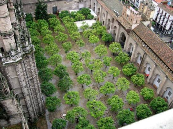
Have you ever been in an orange grove or a palm hammock at Myakka? These are not large trees, but they produce dense shade. In fact, grove owners have to keep pruning their citrus trees in order to keep the canopies from growing together and reducing fruit set.
 |
This is the Patio of the Oranges in the Seville Cathedral, Sevilla, Spain.
Not a closed canopy, but more than what the City is proposing with Royal Palms. |
Another approach would be cabbage palms, which are more or less the opposite of Royal Palms: they are common, not majestic, grow slowly, have light-blocking fan-shaped leaves. Admittedly, it might take as many as 114 cabbage palms (see illustration) to produce significant shade between Main and First, but they would have several advantages over dicotyledonous trees.
 |
Ten acre portion of Myakka River State Park with closed canopy
consisting almost exclusively of cabbage palms |
 |
| Sometimes planting many small trees may work better than a few large trees |
Cabbage palms lack secondary growth – their trunks grow up, but not out, so the trunk ten inches above ground is virtually the same diameter as the trunk ten feet above ground. More importantly perhaps, the roots don’t increase in girth, so paver lifting is not an issue. Cabbage palms are proven to do well with NO tree wells – check out these on Calle Ocho in Miami.
 |
These cabbage palms are growing right out of the sidewalk with no soil in sight.
They are producing lots of shade, just not close enough to each other. |
You already know they don’t lift pavers, don’t necessary need a tree well, and they grow slowly so their shady canopies don’t soar out of reach.
Here are more than a dozen things you may not know about cabbage palms.
Cabbage palms are not bothered by flood, fire, or frost and, according to research conducted after Charley, Frances, Ivan, and Jean cabbage palms are our most wind tolerant native tree.*
Unlike oaks and pines, cabbage palms are insect pollinated, which means they are great for pollinators and do not contribute to human allergies or leave a film of pollen on cars.
Cabbage palms can be planted in narrow spaces, within a few feet of a building and do well (see photo below).
Cabbage palms are arguably the most sustainable tree since they are not intensively grown with irrigation, fertilization and biocides in nurseries from seed, but are sustainably harvested on ranches.
Cabbage palms don't have branches, so kids and drunk adults are not tempted to climb them. This obviates the need to prune away low branches to appease risk managers concerned about lawsuits.
Although Lethal Bronzing is an emerging threat, cabbage palms are typically disease and pest free once established.
Because the trunks on transplanted cabbage palms don't increase in size there is no need for tree grates and the expense of cutting them away to facilitate trunk growth.
Unlike date palms, cabbage palm fruits are innocuous.
And falling cabbage palm leaves are smaller and less dangerous than date and royal palms leaves.
Cabbage palms can live to be over 200 years old (and Sarasota’s extant landscape trees (cabbage palms) were planted in 1911).
Cabbage palms are the only native tree species that can be successfully relocated at modest cost.
They are not only native to Sarasota, but are our State Tree.
*Pamela Crawford, Stormscaping: Landscaping to Minimize Wind Damage in Florida. Color Garden Publishing, 2005.

 |
| These volunteer cabbage palms demonstrate they can work in tight spaces. |
One more thing.
The space between Main and First on Lemon is the epicenter of our downtown Farmer’s Market. The vast majority of tents used by the vendors are ten by ten feet. As noted earlier, the oaks are planted 30 feet apart and there are intervening light poles. Alternating tree trunks and light poles every fifteen feet along a regular street might make sense, but in a public plaza, it severely limits options for other public uses. In such cases uplighting flush with the sidewalk or "Tivoli lights"on trunks would make far more sense.
 |
| Exterior in-ground light for public space (LED) LIGHTVAULT® 8 LTV8SS KIM Lighting |
 |
| Small lights on tree trunks are soft, festive, and welcoming. |
If lights were co-located with trees, then the palm spacing depicted would allow ten by ten tents to fit neatly between the trees. Since they don’t increase in diameter, vendors could tie their tents to the trunks, eliminating some of the need for weights to secure the tents. So the 114 cabbage palms would provide for somewhere around 42 vendor tents.
 |
| Diagram showing how over forty 10'x10' tents could fit neatly into plaza planting |
I’m advocating for cabbage palms because I know a lot about cabbage palms and I believe people should know more about them before dismissing them. But, as noted, other small trees and shrubs have the potential to create more shade than fewer large trees in a plaza situation. That's because big trees need access to big soil, and the concept of most plazas is to provide stable level footing.
Regarding the project south of Main:
1) Demetra MacBride wrote to say: "I would never place Royal Palms in a space with heavy pedestrian traffic. Their habit is to arbitrarily drop limbs which, on that species, are quite heavy. Not a wise risk mitigation strategy." While fronds aren't limbs, she has a point. Royal palms are "self-cleaning" -- their fronds fall off on their own and they are big, in part because they have a long, green crownshaft.
According to Dr. Larry Neal: "Leaves of mature Royal Palms may weigh up to 100 pounds* and the leaf sheath may be large enough to wrap around a person like a hot-dog in a bun, while the leaf blade may be ten feet long (Figure 33). They can fall without warning, although this most often happens during windy weather. You don’t want to be underneath one of these when it falls!"
* I think he is off by an order of magnitude. Still, I don't know anyone that wants to be hit on the head by a ten pound object falling from 50 feet (or more) up.
In order to avoid this liability, the city would have to preemptively remove part of the fronds as they age. I’ve seen mature height maxima for Royal Palms anywhere from 50‘ to 120’. That could be a measurable expense. But even at 50 feet, the shade cast by the trees can end upon the sides of buildings rather than on the streetscape below.
 |
Fallen Royal Palm frond
Photo by Dr. Larry Neel |
2) I think placing street identifier icons in the center of intersections is very problematic. The current proposal calls for a Lemon at the T- intersection of State and Lemon, and a Pineapple at the intersection of Lemon/McAnsh Square and Pineapple. I believe starting this trend will lead to wayfinding problems precisely because the icons are being placed in the intersection of TWO streets. Linking an intersection to only one street is not helpful. So, for example, a naive driver on Pineapple may not know they are on Pineapple. Then they see the pineapple icon and could easily assume it indicates not that they are on Pineapple, but rather that the icon marks the start of Pineapple. So they turn on what they think is Pineapple, but are now on Lemon. Confusion ensues.

I support the gradual introduction of street identifier icons in downtown Sarasota to aid visitors in navigating (because we don't use the more traditional street and avenue approach), but these icons need to be placed outside the intersections.
In the example below, drivers traveling on Orange would see an orange icon aligned with their direction of travel. As they approach Dolphin, they would see a dolphin icon with a bar perpendicular to their direction of travel, indicating a cross street.
 |
Conceptual Icon Street Identifiers Intersection of Dolphin EW and Orange NS
Dolphin icon from
|
title="Flaticon">www.flaticon.com is licensed by
title="Creative Commons BY 3.0" target="_blank">CC 3.0 BY
Here's a link to a related Sarasota Herald Tribune article.
I will review comments and post those on topic.


